|
|
|||||||||||||||||
| Point ID: 3687 | Downloads | Plots | Site Data | Code: 10SB001 |
|
|
|||||||||||||||||
| Download | |
|---|---|
| Site Descriptor Information | Site Time Series Data |
| Link to all available data | |
| View: | Time Series | All |
| Units: | m3/s |
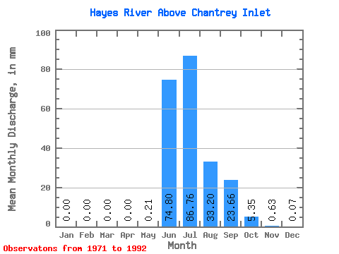
| Statistic | Jan | Feb | Mar | Apr | May | Jun | Jul | Aug | Sep | Oct | Nov | Dec | Annual |
|---|---|---|---|---|---|---|---|---|---|---|---|---|---|
| Mean | 0.00 | 0.00 | 0.00 | 0.00 | 0.21 | 74.80 | 86.74 | 33.20 | 23.66 | 5.34 | 0.63 | 0.07 | 209.80 |
| Standard Deviation | 0.00 | 0.00 | 0.00 | 0.00 | 0.49 | 40.30 | 58.22 | 19.64 | 10.94 | 3.40 | 1.09 | 0.24 | 51.51 |
| Min | 0.00 | 0.00 | 0.00 | 0.00 | 0.00 | 0.14 | 22.05 | 9.16 | 5.00 | 0.00 | 0.00 | 0.00 | 109.83 |
| Max | 0.00 | 0.00 | 0.00 | 0.00 | 2.01 | 133.90 | 263.36 | 84.63 | 47.40 | 14.51 | 4.68 | 1.04 | 280.52 |
| Coefficient of Variation | 2.37 | 0.54 | 0.67 | 0.59 | 0.46 | 0.64 | 1.74 | 3.47 | 0.25 |
 Return to R-Arctic Net Home Page