|
|
|||||||||||||||||
| Point ID: 3683 | Downloads | Plots | Site Data | Code: 10QD001 |
|
|
|||||||||||||||||
| Download | |
|---|---|
| Site Descriptor Information | Site Time Series Data |
| Link to all available data | |
| View: | Time Series | All |
| Units: | m3/s |
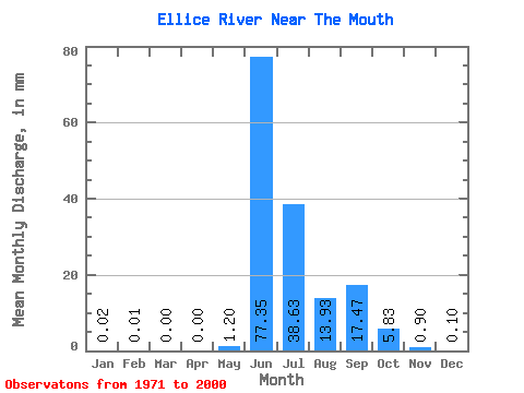
| Statistic | Jan | Feb | Mar | Apr | May | Jun | Jul | Aug | Sep | Oct | Nov | Dec | Annual |
|---|---|---|---|---|---|---|---|---|---|---|---|---|---|
| Mean | 0.02 | 0.01 | 0.00 | 0.00 | 1.20 | 77.35 | 38.62 | 13.93 | 17.47 | 5.83 | 0.90 | 0.10 | 155.91 |
| Standard Deviation | 0.06 | 0.02 | 0.00 | 0.00 | 4.49 | 24.92 | 20.08 | 8.44 | 13.29 | 4.17 | 0.85 | 0.16 | 41.93 |
| Min | 0.00 | 0.00 | 0.00 | 0.00 | 0.00 | 14.71 | 12.20 | 4.56 | 3.79 | 1.17 | 0.01 | 0.00 | 88.06 |
| Max | 0.24 | 0.08 | 0.01 | 0.00 | 22.03 | 117.79 | 94.76 | 39.77 | 59.51 | 15.02 | 3.05 | 0.66 | 256.12 |
| Coefficient of Variation | 3.09 | 3.61 | 3.63 | 3.75 | 0.32 | 0.52 | 0.61 | 0.76 | 0.72 | 0.94 | 1.65 | 0.27 |
 Return to R-Arctic Net Home Page