|
|
|||||||||||||||||
| Point ID: 3681 | Downloads | Plots | Site Data | Code: 10QC001 |
|
|
|||||||||||||||||
| Download | |
|---|---|
| Site Descriptor Information | Site Time Series Data |
| Link to all available data | |
| View: | Time Series | All |
| Units: | m3/s |
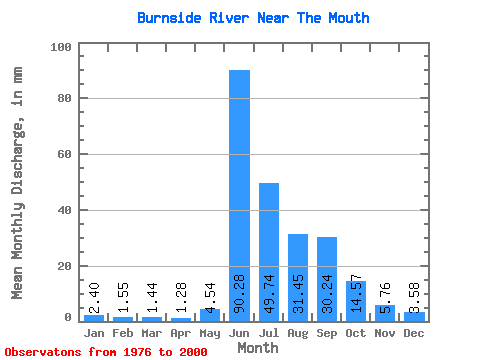
| Statistic | Jan | Feb | Mar | Apr | May | Jun | Jul | Aug | Sep | Oct | Nov | Dec | Annual |
|---|---|---|---|---|---|---|---|---|---|---|---|---|---|
| Mean | 2.40 | 1.57 | 1.44 | 1.28 | 4.54 | 90.28 | 49.73 | 31.44 | 30.24 | 14.57 | 5.76 | 3.58 | 238.09 |
| Standard Deviation | 1.36 | 1.08 | 0.98 | 0.76 | 9.49 | 37.77 | 16.23 | 8.63 | 16.93 | 6.21 | 2.24 | 1.56 | 72.67 |
| Min | 0.40 | 0.10 | 0.00 | 0.00 | 0.42 | 26.54 | 24.87 | 20.56 | 13.44 | 5.15 | 1.50 | 0.74 | 126.79 |
| Max | 4.91 | 3.72 | 3.38 | 2.76 | 43.68 | 148.11 | 81.78 | 52.12 | 88.56 | 31.72 | 12.10 | 7.25 | 359.93 |
| Coefficient of Variation | 0.57 | 0.69 | 0.68 | 0.60 | 2.09 | 0.42 | 0.33 | 0.28 | 0.56 | 0.43 | 0.39 | 0.43 | 0.30 |
 Return to R-Arctic Net Home Page