|
|
|||||||||||||||||
| Point ID: 3680 | Downloads | Plots | Site Data | Code: 10QA001 |
|
|
|||||||||||||||||
| Download | |
|---|---|
| Site Descriptor Information | Site Time Series Data |
| Link to all available data | |
| View: | Time Series | All |
| Units: | m3/s |
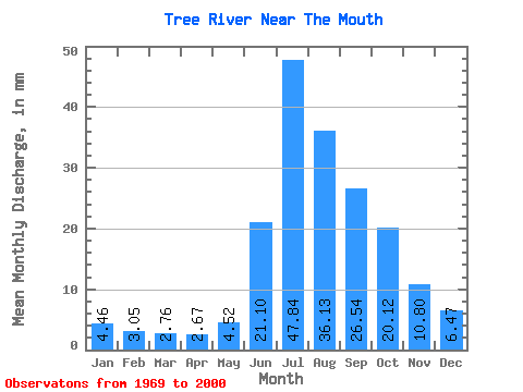
| Statistic | Jan | Feb | Mar | Apr | May | Jun | Jul | Aug | Sep | Oct | Nov | Dec | Annual |
|---|---|---|---|---|---|---|---|---|---|---|---|---|---|
| Mean | 4.46 | 3.07 | 2.76 | 2.67 | 4.52 | 21.10 | 47.83 | 36.12 | 26.54 | 20.11 | 10.80 | 6.47 | 189.66 |
| Standard Deviation | 1.73 | 1.26 | 1.13 | 0.79 | 1.51 | 8.36 | 14.86 | 9.94 | 8.37 | 7.02 | 3.75 | 2.33 | 35.92 |
| Min | 1.36 | 0.90 | 0.54 | 0.29 | 0.24 | 6.65 | 23.00 | 21.99 | 16.64 | 11.20 | 5.58 | 2.96 | 133.03 |
| Max | 9.36 | 6.47 | 5.67 | 3.96 | 6.68 | 38.32 | 81.12 | 69.14 | 47.29 | 40.01 | 19.36 | 12.49 | 263.14 |
| Coefficient of Variation | 0.39 | 0.41 | 0.41 | 0.30 | 0.33 | 0.40 | 0.31 | 0.28 | 0.32 | 0.35 | 0.35 | 0.36 | 0.19 |
 Return to R-Arctic Net Home Page