|
|
|||||||||||||||||
| Point ID: 3676 | Downloads | Plots | Site Data | Code: 10PC001 |
|
|
|||||||||||||||||
| Download | |
|---|---|
| Site Descriptor Information | Site Time Series Data |
| Link to all available data | |
| View: | Time Series | All |
| Units: | m3/s |
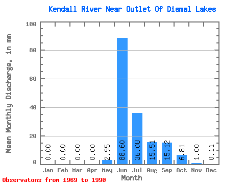
| Statistic | Jan | Feb | Mar | Apr | May | Jun | Jul | Aug | Sep | Oct | Nov | Dec | Annual |
|---|---|---|---|---|---|---|---|---|---|---|---|---|---|
| Mean | 0.00 | 0.00 | 0.00 | 0.00 | 2.95 | 88.60 | 36.08 | 15.51 | 15.12 | 6.81 | 1.00 | 0.11 | 169.35 |
| Standard Deviation | 0.00 | 0.00 | 0.00 | 0.00 | 6.36 | 19.46 | 13.85 | 7.84 | 12.99 | 5.97 | 1.51 | 0.32 | 32.21 |
| Min | 0.00 | 0.00 | 0.00 | 0.00 | 0.00 | 61.69 | 17.76 | 7.53 | 2.90 | 0.26 | 0.00 | 0.00 | 109.80 |
| Max | 0.01 | 0.00 | 0.00 | 0.00 | 22.84 | 127.28 | 64.02 | 44.92 | 44.41 | 18.72 | 5.60 | 1.08 | 222.72 |
| Coefficient of Variation | 4.12 | 2.15 | 0.22 | 0.38 | 0.51 | 0.86 | 0.88 | 1.51 | 3.04 | 0.19 |
 Return to R-Arctic Net Home Page