|
|
|||||||||||||||||
| Point ID: 3662 | Downloads | Plots | Site Data | Code: 10MC002 |
|
|
|||||||||||||||||
| Download | |
|---|---|
| Site Descriptor Information | Site Time Series Data |
| Link to all available data | |
| View: | Time Series | All |
| Units: | m3/s |
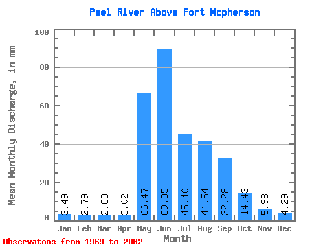
| Statistic | Jan | Feb | Mar | Apr | May | Jun | Jul | Aug | Sep | Oct | Nov | Dec | Annual |
|---|---|---|---|---|---|---|---|---|---|---|---|---|---|
| Mean | 3.49 | 2.81 | 2.88 | 3.02 | 66.45 | 89.35 | 45.39 | 41.54 | 32.28 | 14.43 | 5.98 | 4.29 | 307.97 |
| Standard Deviation | 0.75 | 0.61 | 0.61 | 0.91 | 27.19 | 26.54 | 16.85 | 15.15 | 9.19 | 3.45 | 1.61 | 1.05 | 45.06 |
| Min | 1.95 | 1.67 | 1.78 | 1.77 | 14.11 | 53.23 | 24.28 | 19.16 | 15.64 | 8.57 | 3.56 | 2.59 | 210.53 |
| Max | 5.27 | 4.18 | 4.21 | 6.61 | 107.73 | 146.86 | 89.52 | 84.21 | 55.80 | 23.21 | 10.06 | 8.35 | 410.35 |
| Coefficient of Variation | 0.22 | 0.22 | 0.21 | 0.30 | 0.41 | 0.30 | 0.37 | 0.36 | 0.28 | 0.24 | 0.27 | 0.24 | 0.15 |
 Return to R-Arctic Net Home Page