|
|
|||||||||||||||||
| Point ID: 3658 | Downloads | Plots | Site Data | Code: 10LC009 |
|
|
|||||||||||||||||
| Download | |
|---|---|
| Site Descriptor Information | Site Time Series Data |
| Link to all available data | |
| View: | Time Series | All |
| Units: | m3/s |
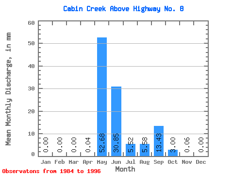
| Statistic | Jan | Feb | Mar | Apr | May | Jun | Jul | Aug | Sep | Oct | Nov | Dec | Annual |
|---|---|---|---|---|---|---|---|---|---|---|---|---|---|
| Mean | 0.00 | 0.00 | 0.00 | 0.03 | 52.68 | 30.84 | 5.53 | 5.58 | 13.43 | 3.00 | 0.06 | 0.00 | 110.60 |
| Standard Deviation | 0.00 | 0.00 | 0.00 | 0.12 | 24.40 | 13.41 | 6.14 | 5.28 | 8.46 | 3.61 | 0.11 | 0.00 | 26.44 |
| Min | 0.00 | 0.00 | 0.00 | 0.00 | 0.00 | 13.12 | 0.58 | 0.08 | 0.76 | 0.04 | 0.00 | 0.00 | 73.48 |
| Max | 0.00 | 0.00 | 0.00 | 0.43 | 96.45 | 60.61 | 20.04 | 15.50 | 25.14 | 11.50 | 0.39 | 0.00 | 151.37 |
| Coefficient of Variation | 3.61 | 0.46 | 0.43 | 1.11 | 0.94 | 0.63 | 1.20 | 2.06 | 0.24 |
 Return to R-Arctic Net Home Page