|
|
|||||||||||||||||
| Point ID: 3650 | Downloads | Plots | Site Data | Code: 10LA002 |
|
|
|||||||||||||||||
| Download | |
|---|---|
| Site Descriptor Information | Site Time Series Data |
| Link to all available data | |
| View: | Time Series | All |
| Units: | m3/s |
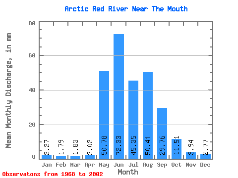
| Statistic | Jan | Feb | Mar | Apr | May | Jun | Jul | Aug | Sep | Oct | Nov | Dec | Annual |
|---|---|---|---|---|---|---|---|---|---|---|---|---|---|
| Mean | 2.27 | 1.81 | 1.83 | 2.02 | 50.77 | 72.33 | 45.34 | 50.40 | 29.76 | 11.51 | 3.94 | 2.77 | 273.36 |
| Standard Deviation | 0.57 | 0.45 | 0.44 | 0.56 | 27.20 | 23.55 | 13.33 | 26.50 | 11.28 | 4.01 | 1.40 | 0.71 | 53.43 |
| Min | 1.04 | 1.03 | 1.08 | 1.25 | 2.71 | 33.17 | 27.36 | 15.41 | 7.46 | 5.08 | 1.73 | 1.16 | 173.72 |
| Max | 3.50 | 2.77 | 2.89 | 4.18 | 112.16 | 113.44 | 83.08 | 139.66 | 52.54 | 20.01 | 7.72 | 4.25 | 389.01 |
| Coefficient of Variation | 0.25 | 0.25 | 0.24 | 0.28 | 0.54 | 0.33 | 0.29 | 0.53 | 0.38 | 0.35 | 0.35 | 0.26 | 0.20 |
 Return to R-Arctic Net Home Page