|
|
|||||||||||||||||
| Point ID: 3640 | Downloads | Plots | Site Data | Code: 10JD002 |
|
|
|||||||||||||||||
| Download | |
|---|---|
| Site Descriptor Information | Site Time Series Data |
| Link to all available data | |
| View: | Time Series | All |
| Units: | m3/s |
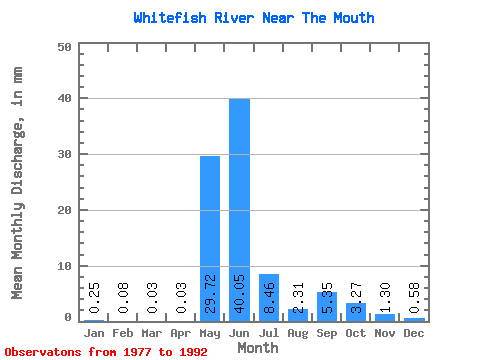
| Statistic | Jan | Feb | Mar | Apr | May | Jun | Jul | Aug | Sep | Oct | Nov | Dec | Annual |
|---|---|---|---|---|---|---|---|---|---|---|---|---|---|
| Mean | 0.25 | 0.08 | 0.03 | 0.03 | 29.71 | 40.05 | 8.46 | 2.31 | 5.35 | 3.27 | 1.30 | 0.58 | 90.77 |
| Standard Deviation | 0.20 | 0.08 | 0.04 | 0.04 | 19.50 | 18.95 | 4.48 | 1.53 | 9.80 | 3.82 | 1.13 | 0.45 | 27.75 |
| Min | 0.01 | 0.00 | 0.00 | 0.00 | 6.10 | 11.10 | 3.71 | 0.72 | 0.42 | 0.47 | 0.20 | 0.08 | 48.36 |
| Max | 0.78 | 0.28 | 0.13 | 0.14 | 74.01 | 77.10 | 18.59 | 5.36 | 32.87 | 14.29 | 4.58 | 1.87 | 139.95 |
| Coefficient of Variation | 0.78 | 0.96 | 1.40 | 1.23 | 0.66 | 0.47 | 0.53 | 0.66 | 1.83 | 1.17 | 0.87 | 0.77 | 0.31 |
 Return to R-Arctic Net Home Page