|
|
|||||||||||||||||
| Point ID: 364 | Downloads | Plots | Site Data | Code: 05CA009 |
|
|
|||||||||||||||||
| Download | |
|---|---|
| Site Descriptor Information | Site Time Series Data |
| Link to all available data | |
| View: | Time Series | All |
| Units: | m3/s |
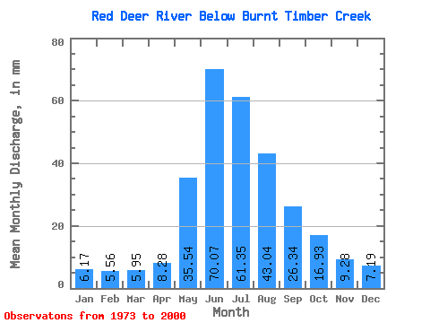
| Statistic | Jan | Feb | Mar | Apr | May | Jun | Jul | Aug | Sep | Oct | Nov | Dec | Annual |
|---|---|---|---|---|---|---|---|---|---|---|---|---|---|
| Mean | 6.17 | 5.61 | 5.95 | 8.28 | 35.53 | 70.07 | 61.34 | 43.03 | 26.34 | 16.92 | 9.28 | 7.19 | 292.28 |
| Standard Deviation | 1.19 | 0.96 | 1.10 | 1.29 | 16.85 | 28.98 | 24.20 | 13.05 | 6.44 | 4.80 | 2.04 | 1.59 | 67.35 |
| Min | 4.07 | 3.71 | 4.04 | 6.47 | 14.16 | 32.14 | 30.23 | 28.33 | 17.39 | 12.38 | 5.74 | 4.14 | 201.46 |
| Max | 8.82 | 7.45 | 8.91 | 11.75 | 77.84 | 142.85 | 120.21 | 79.86 | 42.97 | 37.49 | 16.70 | 12.02 | 426.38 |
| Coefficient of Variation | 0.19 | 0.17 | 0.18 | 0.16 | 0.47 | 0.41 | 0.40 | 0.30 | 0.24 | 0.28 | 0.22 | 0.22 | 0.23 |
 Return to R-Arctic Net Home Page