|
|
|||||||||||||||||
| Point ID: 3637 | Downloads | Plots | Site Data | Code: 10JB001 |
|
|
|||||||||||||||||
| Download | |
|---|---|
| Site Descriptor Information | Site Time Series Data |
| Link to all available data | |
| View: | Time Series | All |
| Units: | m3/s |
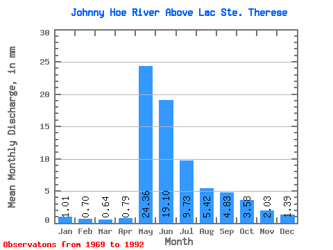
| Statistic | Jan | Feb | Mar | Apr | May | Jun | Jul | Aug | Sep | Oct | Nov | Dec | Annual |
|---|---|---|---|---|---|---|---|---|---|---|---|---|---|
| Mean | 1.01 | 0.71 | 0.64 | 0.79 | 24.35 | 19.10 | 9.72 | 5.42 | 4.83 | 3.58 | 2.03 | 1.39 | 74.06 |
| Standard Deviation | 0.59 | 0.42 | 0.38 | 0.59 | 10.42 | 8.46 | 3.82 | 2.41 | 4.07 | 2.89 | 1.46 | 0.83 | 21.06 |
| Min | 0.33 | 0.24 | 0.15 | 0.13 | 11.64 | 6.49 | 5.65 | 2.28 | 1.34 | 0.90 | 0.61 | 0.41 | 40.19 |
| Max | 2.15 | 1.64 | 1.54 | 2.56 | 47.83 | 33.11 | 20.59 | 10.80 | 18.43 | 11.13 | 5.44 | 3.25 | 117.10 |
| Coefficient of Variation | 0.58 | 0.60 | 0.59 | 0.75 | 0.43 | 0.44 | 0.39 | 0.44 | 0.84 | 0.81 | 0.72 | 0.60 | 0.28 |
 Return to R-Arctic Net Home Page