|
|
|||||||||||||||||
| Point ID: 3635 | Downloads | Plots | Site Data | Code: 10JA002 |
|
|
|||||||||||||||||
| Download | |
|---|---|
| Site Descriptor Information | Site Time Series Data |
| Link to all available data | |
| View: | Time Series | All |
| Units: | m3/s |
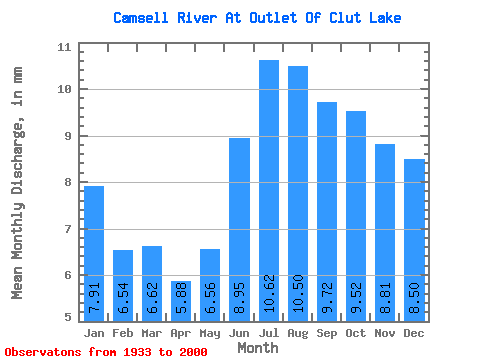
| Statistic | Jan | Feb | Mar | Apr | May | Jun | Jul | Aug | Sep | Oct | Nov | Dec | Annual |
|---|---|---|---|---|---|---|---|---|---|---|---|---|---|
| Mean | 7.90 | 6.59 | 6.62 | 5.88 | 6.56 | 8.95 | 10.62 | 10.50 | 9.72 | 9.52 | 8.81 | 8.50 | 99.92 |
| Standard Deviation | 2.16 | 1.80 | 1.75 | 1.44 | 1.63 | 2.31 | 2.83 | 2.97 | 2.88 | 2.83 | 2.52 | 2.47 | 23.81 |
| Min | 3.87 | 2.53 | 2.71 | 3.29 | 3.89 | 5.51 | 5.96 | 5.38 | 4.68 | 4.50 | 4.05 | 3.67 | 61.07 |
| Max | 13.43 | 10.51 | 10.25 | 8.83 | 10.07 | 13.42 | 16.10 | 17.91 | 18.50 | 18.69 | 17.00 | 15.67 | 165.66 |
| Coefficient of Variation | 0.27 | 0.27 | 0.26 | 0.24 | 0.25 | 0.26 | 0.27 | 0.28 | 0.30 | 0.30 | 0.29 | 0.29 | 0.24 |
 Return to R-Arctic Net Home Page