|
|
|||||||||||||||||
| Point ID: 3632 | Downloads | Plots | Site Data | Code: 10HC003 |
|
|
|||||||||||||||||
| Download | |
|---|---|
| Site Descriptor Information | Site Time Series Data |
| Link to all available data | |
| View: | Time Series | All |
| Units: | m3/s |
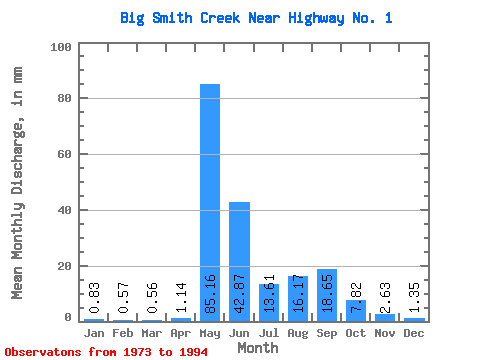
| Statistic | Jan | Feb | Mar | Apr | May | Jun | Jul | Aug | Sep | Oct | Nov | Dec | Annual |
|---|---|---|---|---|---|---|---|---|---|---|---|---|---|
| Mean | 0.82 | 0.58 | 0.56 | 1.14 | 85.15 | 42.87 | 13.61 | 16.17 | 18.65 | 7.82 | 2.63 | 1.35 | 190.93 |
| Standard Deviation | 0.37 | 0.32 | 0.36 | 1.07 | 27.28 | 25.79 | 9.46 | 22.70 | 30.26 | 4.69 | 1.13 | 0.43 | 71.52 |
| Min | 0.03 | 0.01 | 0.01 | 0.18 | 36.67 | 8.04 | 4.00 | 2.02 | 1.58 | 2.09 | 1.25 | 0.38 | 89.02 |
| Max | 1.59 | 1.30 | 1.27 | 5.00 | 128.62 | 85.23 | 43.34 | 83.34 | 118.31 | 19.14 | 5.35 | 2.24 | 350.85 |
| Coefficient of Variation | 0.45 | 0.55 | 0.64 | 0.94 | 0.32 | 0.60 | 0.69 | 1.40 | 1.62 | 0.60 | 0.43 | 0.32 | 0.38 |
 Return to R-Arctic Net Home Page