|
|
|||||||||||||||||
| Point ID: 3628 | Downloads | Plots | Site Data | Code: 10HB001 |
|
|
|||||||||||||||||
| Download | |
|---|---|
| Site Descriptor Information | Site Time Series Data |
| Link to all available data | |
| View: | Time Series | All |
| Units: | m3/s |
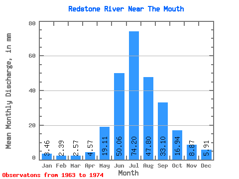
| Statistic | Jan | Feb | Mar | Apr | May | Jun | Jul | Aug | Sep | Oct | Nov | Dec | Annual |
|---|---|---|---|---|---|---|---|---|---|---|---|---|---|
| Mean | 3.46 | 2.41 | 2.57 | 4.57 | 19.11 | 50.06 | 74.19 | 47.79 | 33.10 | 16.94 | 8.87 | 5.91 | |
| Standard Deviation | 1.86 | 0.96 | 0.93 | 1.68 | 12.63 | 14.39 | 13.64 | 8.85 | 2.94 | 2.42 | 1.91 | ||
| Min | 2.04 | 1.68 | 1.96 | 3.38 | 19.11 | 41.57 | 60.26 | 32.17 | 24.18 | 13.81 | 7.55 | 3.92 | |
| Max | 6.21 | 4.08 | 4.21 | 5.75 | 19.11 | 68.75 | 89.00 | 57.32 | 48.68 | 20.25 | 12.50 | 8.38 | |
| Coefficient of Variation | 0.54 | 0.40 | 0.36 | 0.37 | 0.25 | 0.19 | 0.28 | 0.27 | 0.17 | 0.27 | 0.32 |
 Return to R-Arctic Net Home Page