|
|
|||||||||||||||||
| Point ID: 3605 | Downloads | Plots | Site Data | Other Close Sites | Code: 10ED002 |
|
|
|||||||||||||||||
| Download | |
|---|---|
| Site Descriptor Information | Site Time Series Data |
| Link to all available data | |
| View: | Time Series | All |
| Units: | m3/s |
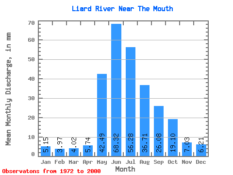
| Statistic | Jan | Feb | Mar | Apr | May | Jun | Jul | Aug | Sep | Oct | Nov | Dec | Annual |
|---|---|---|---|---|---|---|---|---|---|---|---|---|---|
| Mean | 5.15 | 4.00 | 4.02 | 5.74 | 42.48 | 68.31 | 56.27 | 36.71 | 26.08 | 19.09 | 7.03 | 6.21 | 279.36 |
| Standard Deviation | 1.08 | 0.74 | 0.76 | 1.88 | 10.89 | 16.02 | 17.29 | 9.96 | 7.27 | 5.17 | 1.96 | 1.57 | 46.57 |
| Min | 2.92 | 2.81 | 2.74 | 3.59 | 24.83 | 36.85 | 29.31 | 19.96 | 13.29 | 10.32 | 4.62 | 3.50 | 200.92 |
| Max | 7.39 | 5.62 | 5.82 | 10.74 | 67.97 | 103.68 | 100.30 | 57.55 | 41.28 | 31.45 | 11.31 | 9.53 | 395.26 |
| Coefficient of Variation | 0.21 | 0.19 | 0.19 | 0.33 | 0.26 | 0.23 | 0.31 | 0.27 | 0.28 | 0.27 | 0.28 | 0.25 | 0.17 |
| Other Close Sites | ||||||
|---|---|---|---|---|---|---|
| PointID | Latitude | Longitude | Drainage Area | Source | Name | |
| 3622 | "MACKENZIE RIVER AT FORT SIMPSON" | 61.86 | 1611666 | Hydat | ||
 Return to R-Arctic Net Home Page