|
|
|||||||||||||||||
| Point ID: 3603 | Downloads | Plots | Site Data | Code: 10EC002 |
|
|
|||||||||||||||||
| Download | |
|---|---|
| Site Descriptor Information | Site Time Series Data |
| Link to all available data | |
| View: | Time Series | All |
| Units: | m3/s |
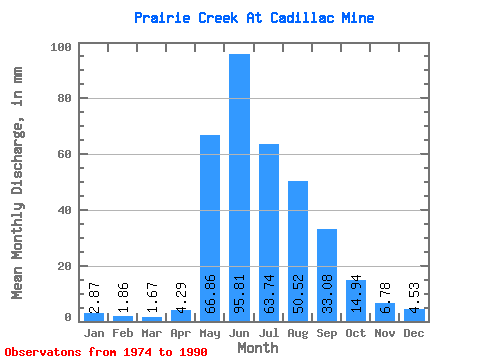
| Statistic | Jan | Feb | Mar | Apr | May | Jun | Jul | Aug | Sep | Oct | Nov | Dec | Annual |
|---|---|---|---|---|---|---|---|---|---|---|---|---|---|
| Mean | 2.87 | 1.88 | 1.67 | 4.29 | 66.86 | 95.81 | 63.73 | 50.51 | 33.08 | 14.95 | 6.77 | 4.54 | 345.37 |
| Standard Deviation | 1.63 | 1.18 | 1.06 | 5.16 | 19.06 | 44.50 | 21.96 | 17.20 | 7.95 | 5.34 | 2.11 | 2.00 | 79.92 |
| Min | 0.78 | 0.24 | 0.21 | 0.41 | 42.41 | 38.02 | 32.24 | 27.70 | 19.16 | 8.33 | 4.34 | 1.37 | 235.18 |
| Max | 6.65 | 4.28 | 3.58 | 22.73 | 99.55 | 195.84 | 106.58 | 91.43 | 47.55 | 30.35 | 12.15 | 9.96 | 502.17 |
| Coefficient of Variation | 0.57 | 0.63 | 0.64 | 1.20 | 0.28 | 0.46 | 0.34 | 0.34 | 0.24 | 0.36 | 0.31 | 0.44 | 0.23 |
 Return to R-Arctic Net Home Page