|
|
|||||||||||||||||
| Point ID: 3597 | Downloads | Plots | Site Data | Code: 10EA003 |
|
|
|||||||||||||||||
| Download | |
|---|---|
| Site Descriptor Information | Site Time Series Data |
| Link to all available data | |
| View: | Time Series | All |
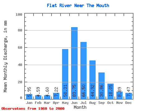
| Units: | m3/s |
| Statistic | Jan | Feb | Mar | Apr | May | Jun | Jul | Aug | Sep | Oct | Nov | Dec | Annual |
|---|---|---|---|---|---|---|---|---|---|---|---|---|---|
| Mean | 5.95 | 4.63 | 4.60 | 7.22 | 58.30 | 83.75 | 66.49 | 44.91 | 30.86 | 18.05 | 8.89 | 7.47 | 345.69 |
| Standard Deviation | 1.22 | 1.01 | 1.09 | 3.55 | 13.46 | 23.20 | 21.57 | 12.38 | 9.05 | 5.26 | 2.56 | 1.79 | 55.49 |
| Min | 3.69 | 1.94 | 1.32 | 3.39 | 24.71 | 45.12 | 37.85 | 25.47 | 16.75 | 7.20 | 4.91 | 4.60 | 254.31 |
| Max | 8.95 | 6.47 | 6.54 | 17.26 | 86.97 | 136.56 | 122.95 | 75.08 | 54.81 | 31.60 | 16.77 | 12.67 | 466.12 |
| Coefficient of Variation | 0.20 | 0.22 | 0.24 | 0.49 | 0.23 | 0.28 | 0.32 | 0.28 | 0.29 | 0.29 | 0.29 | 0.24 | 0.16 |
 Return to R-Arctic Net Home Page