|
|
|||||||||||||||||
| Point ID: 3596 | Downloads | Plots | Site Data | Code: 10EA002 |
|
|
|||||||||||||||||
| Download | |
|---|---|
| Site Descriptor Information | Site Time Series Data |
| Link to all available data | |
| View: | Time Series | All |
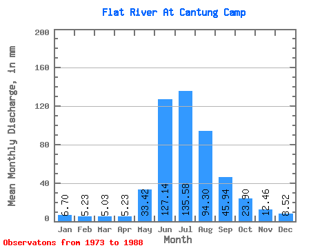
| Units: | m3/s |
| Statistic | Jan | Feb | Mar | Apr | May | Jun | Jul | Aug | Sep | Oct | Nov | Dec | Annual |
|---|---|---|---|---|---|---|---|---|---|---|---|---|---|
| Mean | 6.70 | 5.28 | 5.04 | 5.24 | 33.42 | 127.14 | 135.55 | 94.29 | 45.94 | 23.89 | 12.46 | 8.51 | 500.88 |
| Standard Deviation | 1.29 | 0.93 | 1.09 | 1.25 | 23.83 | 32.23 | 28.79 | 21.59 | 7.91 | 4.19 | 2.46 | 1.93 | 52.10 |
| Min | 5.20 | 3.90 | 3.39 | 3.48 | 16.40 | 86.46 | 99.52 | 59.61 | 30.43 | 18.66 | 9.46 | 6.27 | 429.89 |
| Max | 10.23 | 6.75 | 7.05 | 7.26 | 99.52 | 199.00 | 200.42 | 131.31 | 61.87 | 33.34 | 18.90 | 14.03 | 610.70 |
| Coefficient of Variation | 0.19 | 0.18 | 0.22 | 0.24 | 0.71 | 0.25 | 0.21 | 0.23 | 0.17 | 0.17 | 0.20 | 0.23 | 0.10 |
 Return to R-Arctic Net Home Page