|
|
|||||||||||||||||
| Point ID: 3594 | Downloads | Plots | Site Data | Code: 07TB001 |
|
|
|||||||||||||||||
| Download | |
|---|---|
| Site Descriptor Information | Site Time Series Data |
| Link to all available data | |
| View: | Time Series | All |
| Units: | m3/s |
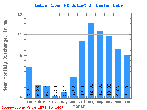
| Statistic | Jan | Feb | Mar | Apr | May | Jun | Jul | Aug | Sep | Oct | Nov | Dec | Annual |
|---|---|---|---|---|---|---|---|---|---|---|---|---|---|
| Mean | 7.91 | 6.33 | 6.12 | 5.23 | 5.57 | 7.03 | 10.36 | 12.08 | 11.35 | 10.85 | 9.66 | 9.10 | 103.04 |
| Standard Deviation | 3.33 | 2.32 | 1.96 | 1.47 | 1.49 | 2.58 | 5.76 | 7.03 | 5.75 | 5.45 | 5.12 | 4.31 | 36.84 |
| Min | 3.95 | 3.48 | 3.66 | 3.29 | 3.59 | 4.06 | 4.31 | 4.29 | 4.07 | 4.18 | 3.75 | 3.92 | 46.99 |
| Max | 17.23 | 12.63 | 11.21 | 8.87 | 8.28 | 11.65 | 22.36 | 29.98 | 24.69 | 24.13 | 25.01 | 21.70 | 178.30 |
| Coefficient of Variation | 0.42 | 0.37 | 0.32 | 0.28 | 0.27 | 0.37 | 0.56 | 0.58 | 0.51 | 0.50 | 0.53 | 0.47 | 0.36 |
 Return to R-Arctic Net Home Page