|
|
|||||||||||||||||
| Point ID: 3593 | Downloads | Plots | Site Data | Code: 07TA001 |
|
|
|||||||||||||||||
| Download | |
|---|---|
| Site Descriptor Information | Site Time Series Data |
| Link to all available data | |
| View: | Time Series | All |
| Units: | m3/s |
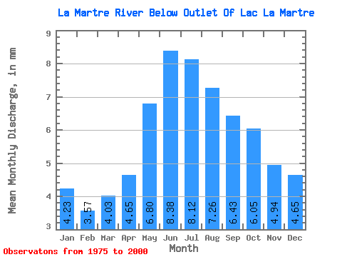
| Statistic | Jan | Feb | Mar | Apr | May | Jun | Jul | Aug | Sep | Oct | Nov | Dec | Annual |
|---|---|---|---|---|---|---|---|---|---|---|---|---|---|
| Mean | 4.22 | 3.60 | 4.03 | 4.65 | 6.80 | 8.38 | 8.12 | 7.26 | 6.43 | 6.05 | 4.94 | 4.65 | 69.92 |
| Standard Deviation | 1.93 | 1.71 | 1.89 | 2.04 | 2.33 | 2.52 | 2.52 | 2.33 | 2.29 | 2.24 | 1.96 | 2.02 | 23.53 |
| Min | 1.98 | 1.70 | 1.50 | 1.68 | 3.68 | 4.72 | 4.61 | 3.85 | 3.36 | 3.27 | 2.26 | 2.04 | 39.60 |
| Max | 8.96 | 7.85 | 8.36 | 8.60 | 11.21 | 13.37 | 13.31 | 11.27 | 10.93 | 10.46 | 9.36 | 9.29 | 116.74 |
| Coefficient of Variation | 0.46 | 0.47 | 0.47 | 0.44 | 0.34 | 0.30 | 0.31 | 0.32 | 0.36 | 0.37 | 0.40 | 0.43 | 0.34 |
 Return to R-Arctic Net Home Page