|
|
|||||||||||||||||
| Point ID: 3590 | Downloads | Plots | Site Data | Code: 07SB013 |
|
|
|||||||||||||||||
| Download | |
|---|---|
| Site Descriptor Information | Site Time Series Data |
| Link to all available data | |
| View: | Time Series | All |
| Units: | m3/s |
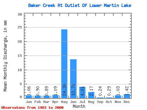
| Statistic | Jan | Feb | Mar | Apr | May | Jun | Jul | Aug | Sep | Oct | Nov | Dec | Annual |
|---|---|---|---|---|---|---|---|---|---|---|---|---|---|
| Mean | 1.06 | 0.90 | 0.88 | 1.10 | 24.29 | 13.71 | 4.01 | 2.18 | 0.23 | 0.29 | 1.02 | 1.42 | 54.25 |
| Standard Deviation | 1.76 | 1.28 | 1.24 | 1.37 | 24.74 | 13.40 | 10.08 | 7.58 | 0.46 | 0.43 | 1.70 | 1.84 | 43.69 |
| Min | 0.00 | 0.00 | 0.00 | 0.00 | 1.86 | 0.64 | 0.04 | 0.00 | 0.00 | 0.00 | 0.00 | 0.00 | 7.85 |
| Max | 5.82 | 3.77 | 3.58 | 4.18 | 86.98 | 49.48 | 42.72 | 30.54 | 1.71 | 1.28 | 5.98 | 5.55 | 155.26 |
| Coefficient of Variation | 1.66 | 1.43 | 1.41 | 1.25 | 1.02 | 0.98 | 2.51 | 3.48 | 2.01 | 1.48 | 1.67 | 1.30 | 0.81 |
 Return to R-Arctic Net Home Page