|
|
|||||||||||||||||
| Point ID: 3588 | Downloads | Plots | Site Data | Code: 07SB010 |
|
|
|||||||||||||||||
| Download | |
|---|---|
| Site Descriptor Information | Site Time Series Data |
| Link to all available data | |
| View: | Time Series | All |
| Units: | m3/s |
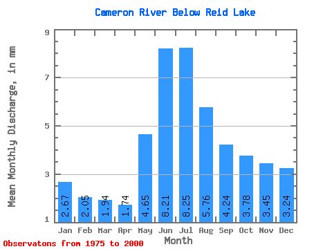
| Statistic | Jan | Feb | Mar | Apr | May | Jun | Jul | Aug | Sep | Oct | Nov | Dec | Annual |
|---|---|---|---|---|---|---|---|---|---|---|---|---|---|
| Mean | 2.67 | 2.07 | 1.94 | 1.74 | 4.65 | 8.21 | 8.25 | 5.76 | 4.24 | 3.78 | 3.45 | 3.24 | 50.05 |
| Standard Deviation | 1.62 | 1.27 | 1.15 | 1.06 | 3.80 | 7.93 | 7.49 | 4.44 | 2.90 | 2.52 | 2.33 | 2.06 | 32.08 |
| Min | 0.83 | 0.58 | 0.42 | 0.30 | 1.03 | 0.75 | 0.38 | 0.19 | 0.28 | 0.56 | 0.81 | 0.95 | 7.75 |
| Max | 6.19 | 5.00 | 4.52 | 4.28 | 11.95 | 34.27 | 29.36 | 16.52 | 10.85 | 9.66 | 9.93 | 8.26 | 130.06 |
| Coefficient of Variation | 0.61 | 0.61 | 0.59 | 0.61 | 0.82 | 0.96 | 0.91 | 0.77 | 0.68 | 0.67 | 0.68 | 0.64 | 0.64 |
 Return to R-Arctic Net Home Page