|
|
|||||||||||||||||
| Point ID: 3582 | Downloads | Plots | Site Data | Other Close Sites | Code: 07SB003 |
|
|
|||||||||||||||||
| Download | |
|---|---|
| Site Descriptor Information | Site Time Series Data |
| Link to all available data | |
| View: | Time Series | All |
| Units: | m3/s |
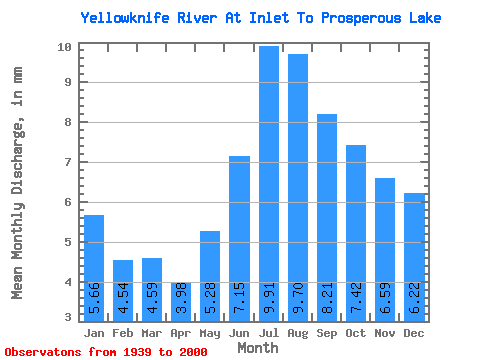
| Statistic | Jan | Feb | Mar | Apr | May | Jun | Jul | Aug | Sep | Oct | Nov | Dec | Annual |
|---|---|---|---|---|---|---|---|---|---|---|---|---|---|
| Mean | 5.66 | 4.58 | 4.59 | 3.98 | 5.28 | 7.15 | 9.90 | 9.70 | 8.21 | 7.42 | 6.59 | 6.21 | 80.56 |
| Standard Deviation | 2.50 | 1.87 | 1.73 | 1.32 | 2.18 | 4.33 | 6.87 | 5.20 | 3.76 | 3.58 | 3.19 | 2.87 | 29.95 |
| Min | 2.33 | 2.22 | 2.54 | 1.57 | 2.39 | 2.27 | 2.21 | 1.69 | 2.08 | 2.80 | 1.54 | 2.27 | 32.68 |
| Max | 12.21 | 10.49 | 10.62 | 9.40 | 13.39 | 25.69 | 36.02 | 22.14 | 18.65 | 17.28 | 15.30 | 13.29 | 148.49 |
| Coefficient of Variation | 0.44 | 0.41 | 0.38 | 0.33 | 0.41 | 0.60 | 0.69 | 0.54 | 0.46 | 0.48 | 0.48 | 0.46 | 0.37 |
| Other Close Sites | ||||||
|---|---|---|---|---|---|---|
| PointID | Latitude | Longitude | Drainage Area | Source | Name | |
| 3581 | "YELLOWKNIFE RIVER AT OUTLET FROM PROSPEROUS LAKE" | 62.54 | 1237837 | Hydat | ||
| 3585 | "YELLOWKNIFE RIVER POWER DIVERSION AT SITE Y2" | 62.66 | 1236846 | Hydat | ||
 Return to R-Arctic Net Home Page