|
|
|||||||||||||||||
| Point ID: 3564 | Downloads | Plots | Site Data | Code: 07PB002 |
|
|
|||||||||||||||||
| Download | |
|---|---|
| Site Descriptor Information | Site Time Series Data |
| Link to all available data | |
| View: | Time Series | All |
| Units: | m3/s |
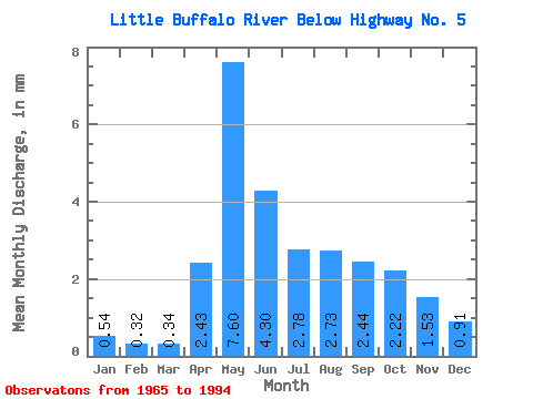
| Statistic | Jan | Feb | Mar | Apr | May | Jun | Jul | Aug | Sep | Oct | Nov | Dec | Annual |
|---|---|---|---|---|---|---|---|---|---|---|---|---|---|
| Mean | 0.54 | 0.32 | 0.34 | 2.43 | 7.60 | 4.30 | 2.78 | 2.73 | 2.44 | 2.22 | 1.53 | 0.91 | 32.12 |
| Standard Deviation | 0.51 | 0.27 | 0.28 | 1.94 | 6.34 | 3.51 | 2.95 | 3.50 | 3.35 | 2.45 | 1.39 | 0.73 | 23.80 |
| Min | 0.00 | 0.00 | 0.00 | 0.46 | 0.59 | 0.19 | 0.05 | 0.03 | 0.08 | 0.11 | 0.09 | 0.00 | 5.74 |
| Max | 1.23 | 0.71 | 0.66 | 6.99 | 21.95 | 13.00 | 12.79 | 13.27 | 11.60 | 9.41 | 4.04 | 1.95 | 63.62 |
| Coefficient of Variation | 0.93 | 0.85 | 0.82 | 0.80 | 0.83 | 0.82 | 1.06 | 1.28 | 1.37 | 1.10 | 0.91 | 0.81 | 0.74 |
 Return to R-Arctic Net Home Page