|
|
|||||||||||||||||
| Point ID: 3561 | Downloads | Plots | Site Data | Code: 07OB001 |
|
|
|||||||||||||||||
| Download | |
|---|---|
| Site Descriptor Information | Site Time Series Data |
| Link to all available data | |
| View: | Time Series | All |
| Units: | m3/s |
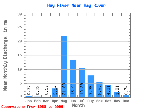
| Statistic | Jan | Feb | Mar | Apr | May | Jun | Jul | Aug | Sep | Oct | Nov | Dec | Annual |
|---|---|---|---|---|---|---|---|---|---|---|---|---|---|
| Mean | 0.40 | 0.23 | 0.18 | 3.36 | 23.38 | 14.36 | 11.12 | 8.30 | 5.96 | 4.62 | 1.94 | 0.80 | 73.91 |
| Standard Deviation | 0.52 | 0.27 | 0.15 | 3.21 | 10.51 | 9.06 | 9.03 | 6.50 | 4.90 | 4.17 | 1.78 | 0.85 | 36.94 |
| Min | 0.07 | 0.03 | 0.02 | 0.06 | 2.14 | 1.56 | 1.07 | 0.62 | 0.27 | 0.34 | 0.24 | 0.14 | 13.10 |
| Max | 3.06 | 1.57 | 0.78 | 9.85 | 45.84 | 41.67 | 47.35 | 28.62 | 18.99 | 20.80 | 9.09 | 4.48 | 162.50 |
| Coefficient of Variation | 1.31 | 1.14 | 0.83 | 0.96 | 0.45 | 0.63 | 0.81 | 0.78 | 0.82 | 0.90 | 0.92 | 1.07 | 0.50 |
 Return to R-Arctic Net Home Page