|
|
|||||||||||||||||
| Point ID: 3541 | Downloads | Plots | Site Data | Code: 06MA006 |
|
|
|||||||||||||||||
| Download | |
|---|---|
| Site Descriptor Information | Site Time Series Data |
| Link to all available data | |
| View: | Time Series | All |
| Units: | m3/s |
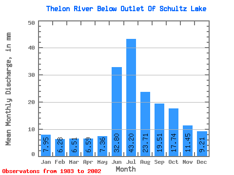
| Statistic | Jan | Feb | Mar | Apr | May | Jun | Jul | Aug | Sep | Oct | Nov | Dec | Annual |
|---|---|---|---|---|---|---|---|---|---|---|---|---|---|
| Mean | 7.95 | 6.33 | 6.51 | 6.59 | 7.36 | 32.80 | 43.19 | 23.70 | 19.51 | 17.74 | 11.45 | 9.21 | 191.79 |
| Standard Deviation | 1.55 | 1.37 | 1.47 | 1.38 | 1.41 | 11.53 | 10.72 | 4.88 | 3.93 | 3.31 | 1.37 | 1.79 | 28.99 |
| Min | 4.86 | 3.66 | 3.98 | 3.96 | 4.19 | 16.46 | 26.07 | 14.61 | 12.77 | 11.03 | 8.90 | 6.80 | 138.84 |
| Max | 10.91 | 8.60 | 9.32 | 9.26 | 9.62 | 59.17 | 60.61 | 32.07 | 24.73 | 22.38 | 14.14 | 12.79 | 248.14 |
| Coefficient of Variation | 0.20 | 0.22 | 0.23 | 0.21 | 0.19 | 0.35 | 0.25 | 0.21 | 0.20 | 0.19 | 0.12 | 0.19 | 0.15 |
 Return to R-Arctic Net Home Page