|
|
|||||||||||||||||
| Point ID: 3538 | Downloads | Plots | Site Data | Code: 06MA003 |
|
|
|||||||||||||||||
| Download | |
|---|---|
| Site Descriptor Information | Site Time Series Data |
| Link to all available data | |
| View: | Time Series | All |
| Units: | m3/s |
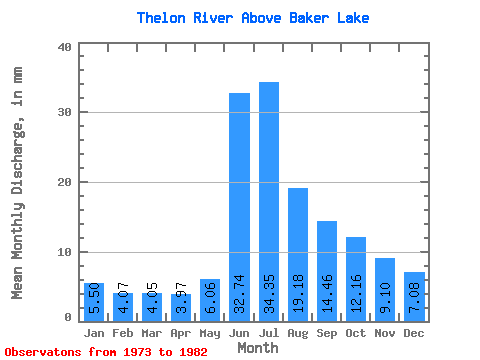
| Statistic | Jan | Feb | Mar | Apr | May | Jun | Jul | Aug | Sep | Oct | Nov | Dec | Annual |
|---|---|---|---|---|---|---|---|---|---|---|---|---|---|
| Mean | 5.50 | 4.11 | 4.05 | 3.97 | 6.06 | 32.74 | 34.34 | 19.18 | 14.46 | 12.16 | 9.10 | 7.08 | 154.64 |
| Standard Deviation | 0.82 | 0.58 | 0.78 | 1.08 | 3.12 | 9.46 | 10.10 | 4.94 | 1.45 | 2.46 | 1.62 | 0.73 | 13.73 |
| Min | 4.42 | 3.22 | 2.97 | 2.46 | 2.35 | 17.00 | 23.82 | 12.19 | 12.34 | 7.84 | 6.11 | 5.95 | 134.52 |
| Max | 7.27 | 5.13 | 5.53 | 5.35 | 13.01 | 42.25 | 54.95 | 30.95 | 16.83 | 17.02 | 12.27 | 8.40 | 169.74 |
| Coefficient of Variation | 0.15 | 0.14 | 0.19 | 0.27 | 0.52 | 0.29 | 0.29 | 0.26 | 0.10 | 0.20 | 0.18 | 0.10 | 0.09 |
 Return to R-Arctic Net Home Page