|
|
|||||||||||||||||
| Point ID: 3537 | Downloads | Plots | Site Data | Code: 06MA002 |
|
|
|||||||||||||||||
| Download | |
|---|---|
| Site Descriptor Information | Site Time Series Data |
| Link to all available data | |
| View: | Time Series | All |
| Units: | m3/s |
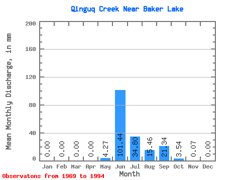
| Statistic | Jan | Feb | Mar | Apr | May | Jun | Jul | Aug | Sep | Oct | Nov | Dec | Annual |
|---|---|---|---|---|---|---|---|---|---|---|---|---|---|
| Mean | 0.00 | 0.00 | 0.00 | 0.00 | 4.26 | 101.44 | 34.80 | 15.46 | 21.34 | 3.54 | 0.07 | 0.00 | 193.09 |
| Standard Deviation | 0.00 | 0.00 | 0.00 | 0.00 | 11.88 | 48.06 | 18.08 | 14.06 | 22.33 | 4.70 | 0.21 | 0.00 | 64.35 |
| Min | 0.00 | 0.00 | 0.00 | 0.00 | 0.00 | 38.64 | 7.13 | 2.14 | 0.90 | 0.00 | 0.00 | 0.00 | 103.92 |
| Max | 0.00 | 0.00 | 0.00 | 0.00 | 49.90 | 223.80 | 75.63 | 59.63 | 102.60 | 19.71 | 0.97 | 0.00 | 306.49 |
| Coefficient of Variation | 2.79 | 0.47 | 0.52 | 0.91 | 1.05 | 1.33 | 3.10 | 0.33 |
 Return to R-Arctic Net Home Page