|
|
|||||||||||||||||
| Point ID: 3533 | Downloads | Plots | Site Data | Code: 06LA001 |
|
|
|||||||||||||||||
| Download | |
|---|---|
| Site Descriptor Information | Site Time Series Data |
| Link to all available data | |
| View: | Time Series | All |
| Units: | m3/s |
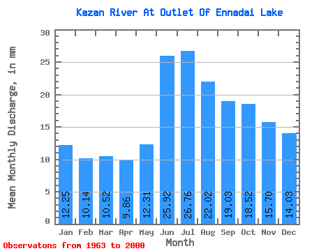
| Statistic | Jan | Feb | Mar | Apr | May | Jun | Jul | Aug | Sep | Oct | Nov | Dec | Annual |
|---|---|---|---|---|---|---|---|---|---|---|---|---|---|
| Mean | 12.24 | 10.23 | 10.52 | 9.86 | 12.31 | 25.92 | 26.75 | 22.02 | 19.03 | 18.51 | 15.70 | 14.03 | 197.85 |
| Standard Deviation | 3.56 | 3.13 | 3.31 | 2.67 | 2.90 | 7.76 | 8.06 | 5.77 | 5.95 | 7.37 | 5.84 | 4.48 | 47.13 |
| Min | 6.17 | 5.23 | 5.81 | 5.76 | 6.89 | 11.24 | 11.46 | 11.01 | 8.03 | 7.47 | 6.82 | 6.62 | 111.65 |
| Max | 22.15 | 18.47 | 18.77 | 15.87 | 17.64 | 40.58 | 46.68 | 37.54 | 36.70 | 47.05 | 35.97 | 26.41 | 329.24 |
| Coefficient of Variation | 0.29 | 0.31 | 0.32 | 0.27 | 0.24 | 0.30 | 0.30 | 0.26 | 0.31 | 0.40 | 0.37 | 0.32 | 0.24 |
 Return to R-Arctic Net Home Page