|
|
|||||||||||||||||
| Point ID: 3529 | Downloads | Plots | Site Data | Code: 06JB001 |
|
|
|||||||||||||||||
| Download | |
|---|---|
| Site Descriptor Information | Site Time Series Data |
| Link to all available data | |
| View: | Time Series | All |
| Units: | m3/s |
| Statistic | Jan | Feb | Mar | Apr | May | Jun | Jul | Aug | Sep | Oct | Nov | Dec | Annual |
|---|---|---|---|---|---|---|---|---|---|---|---|---|---|
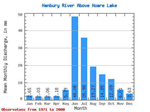
| Mean | 2.65 | 2.04 | 2.06 | 2.18 | 5.79 | 48.08 | 35.97 | 19.27 | 14.85 | 12.09 | 6.01 | 3.63 | 162.04 |
| Standard Deviation | 1.36 | 1.13 | 1.07 | 0.92 | 6.23 | 27.10 | 13.48 | 6.80 | 7.76 | 6.53 | 2.77 | 1.78 | 54.78 |
| Min | 0.73 | 0.45 | 0.33 | 0.37 | 1.92 | 12.35 | 9.75 | 6.27 | 6.15 | 4.59 | 3.07 | 1.66 | 55.61 |
| Max | 5.80 | 4.78 | 4.73 | 4.20 | 27.99 | 140.61 | 68.23 | 37.27 | 40.48 | 30.96 | 14.55 | 9.33 | 283.84 |
| Coefficient of Variation | 0.51 | 0.55 | 0.52 | 0.42 | 1.07 | 0.56 | 0.38 | 0.35 | 0.52 | 0.54 | 0.46 | 0.49 | 0.34 |
 Return to R-Arctic Net Home Page