|
|
|||||||||||||||||
| Point ID: 3526 | Downloads | Plots | Site Data | Code: 06HD001 |
|
|
|||||||||||||||||
| Download | |
|---|---|
| Site Descriptor Information | Site Time Series Data |
| Link to all available data | |
| View: | Time Series | All |
| Units: | m3/s |
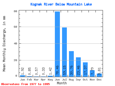
| Statistic | Jan | Feb | Mar | Apr | May | Jun | Jul | Aug | Sep | Oct | Nov | Dec | Annual |
|---|---|---|---|---|---|---|---|---|---|---|---|---|---|
| Mean | 1.92 | 0.86 | 0.57 | 0.33 | 1.42 | 78.46 | 59.14 | 30.76 | 23.46 | 17.36 | 7.79 | 3.81 | 231.78 |
| Standard Deviation | 1.41 | 0.43 | 0.29 | 0.16 | 2.38 | 19.82 | 20.57 | 13.44 | 14.42 | 7.03 | 4.55 | 2.74 | 46.92 |
| Min | 0.00 | 0.00 | 0.00 | 0.00 | 0.03 | 45.08 | 20.34 | 16.38 | 12.28 | 10.71 | 2.38 | 0.40 | 159.42 |
| Max | 5.78 | 1.70 | 1.00 | 0.68 | 7.10 | 107.06 | 89.27 | 75.68 | 72.12 | 36.48 | 16.60 | 9.31 | 338.13 |
| Coefficient of Variation | 0.73 | 0.51 | 0.51 | 0.49 | 1.68 | 0.25 | 0.35 | 0.44 | 0.61 | 0.41 | 0.58 | 0.72 | 0.20 |
 Return to R-Arctic Net Home Page