|
|
|||||||||||||||||
| Point ID: 320 | Downloads | Plots | Site Data | Code: 05BL023 |
|
|
|||||||||||||||||
| Download | |
|---|---|
| Site Descriptor Information | Site Time Series Data |
| Link to all available data | |
| View: | Time Series | All |
| Units: | m3/s |
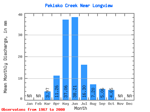
| Statistic | Jan | Feb | Mar | Apr | May | Jun | Jul | Aug | Sep | Oct | Nov | Dec | Annual |
|---|---|---|---|---|---|---|---|---|---|---|---|---|---|
| Mean | 3.97 | 11.26 | 37.05 | 38.20 | 16.30 | 7.21 | 5.06 | 4.66 | |||||
| Standard Deviation | 2.75 | 7.67 | 25.47 | 28.50 | 20.85 | 11.44 | 6.78 | 4.60 | |||||
| Min | 0.27 | 2.99 | 2.94 | 2.38 | 0.52 | 0.05 | 0.06 | 0.20 | |||||
| Max | 11.10 | 35.19 | 98.23 | 120.66 | 78.03 | 52.29 | 33.18 | 18.01 | |||||
| Coefficient of Variation | 0.69 | 0.68 | 0.69 | 0.75 | 1.28 | 1.59 | 1.34 | 0.99 |
 Return to R-Arctic Net Home Page