|
|
|||||||||||||||||
| Point ID: 32 | Downloads | Plots | Site Data | Code: 05AB014 |
|
|
|||||||||||||||||
| Download | |
|---|---|
| Site Descriptor Information | Site Time Series Data |
| Link to all available data | |
| View: | Time Series | All |
| Units: | m3/s |
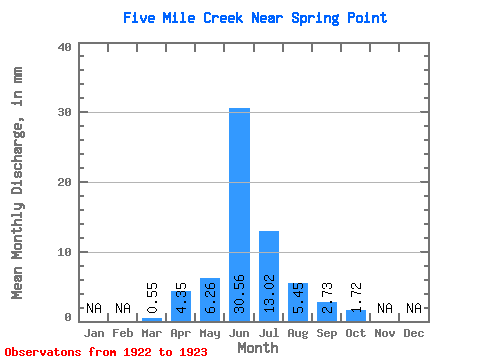
| Statistic | Jan | Feb | Mar | Apr | May | Jun | Jul | Aug | Sep | Oct | Nov | Dec | Annual |
|---|---|---|---|---|---|---|---|---|---|---|---|---|---|
| Mean | 0.53 | 4.34 | 6.28 | 30.56 | 12.99 | 5.47 | 2.76 | 1.69 | |||||
| Standard Deviation | 0.25 | 1.86 | 0.96 | 40.32 | 14.45 | 6.88 | 3.42 | 1.82 | |||||
| Min | 0.35 | 3.03 | 5.60 | 2.05 | 2.77 | 0.60 | 0.34 | 0.40 | |||||
| Max | 0.71 | 5.66 | 6.96 | 59.08 | 23.20 | 10.34 | 5.17 | 2.98 | |||||
| Coefficient of Variation | 0.47 | 0.43 | 0.15 | 1.32 | 1.11 | 1.26 | 1.24 | 1.08 |
 Return to R-Arctic Net Home Page