|
|
|||||||||||||||||
| Point ID: 3132 | Downloads | Plots | Site Data | Code: 06FD002 |
|
|
|||||||||||||||||
| Download | |
|---|---|
| Site Descriptor Information | Site Time Series Data |
| Link to all available data | |
| View: | Time Series | All |
| Units: | m3/s |
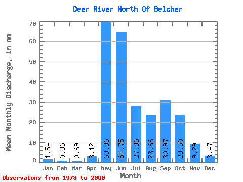
| Statistic | Jan | Feb | Mar | Apr | May | Jun | Jul | Aug | Sep | Oct | Nov | Dec | Annual |
|---|---|---|---|---|---|---|---|---|---|---|---|---|---|
| Mean | 1.54 | 0.86 | 0.69 | 3.12 | 69.95 | 64.75 | 27.95 | 23.65 | 30.97 | 23.50 | 9.29 | 3.47 | 249.88 |
| Standard Deviation | 0.94 | 0.50 | 0.40 | 6.92 | 42.84 | 44.89 | 21.71 | 19.93 | 31.09 | 21.33 | 7.68 | 2.93 | 106.29 |
| Min | 0.26 | 0.08 | 0.03 | 0.02 | 4.60 | 26.89 | 5.58 | 3.79 | 3.71 | 4.66 | 2.22 | 0.78 | 117.20 |
| Max | 3.92 | 1.78 | 1.52 | 24.82 | 155.27 | 226.11 | 86.04 | 69.66 | 108.92 | 98.86 | 32.26 | 14.02 | 470.60 |
| Coefficient of Variation | 0.61 | 0.58 | 0.58 | 2.22 | 0.61 | 0.69 | 0.78 | 0.84 | 1.00 | 0.91 | 0.83 | 0.84 | 0.42 |
 Return to R-Arctic Net Home Page