|
|
|||||||||||||||||
| Point ID: 3130 | Downloads | Plots | Site Data | Code: 06FC001 |
|
|
|||||||||||||||||
| Download | |
|---|---|
| Site Descriptor Information | Site Time Series Data |
| Link to all available data | |
| View: | Time Series | All |
| Units: | m3/s |
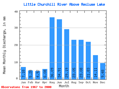
| Statistic | Jan | Feb | Mar | Apr | May | Jun | Jul | Aug | Sep | Oct | Nov | Dec | Annual |
|---|---|---|---|---|---|---|---|---|---|---|---|---|---|
| Mean | 7.18 | 5.32 | 4.92 | 6.08 | 36.08 | 34.91 | 29.18 | 23.05 | 23.08 | 21.83 | 14.11 | 9.47 | 215.34 |
| Standard Deviation | 3.21 | 2.12 | 1.46 | 3.67 | 18.13 | 11.67 | 14.91 | 13.45 | 14.74 | 13.00 | 8.22 | 4.67 | 61.89 |
| Min | 2.49 | 1.81 | 2.60 | 2.42 | 4.79 | 12.58 | 10.88 | 7.19 | 6.25 | 6.41 | 4.51 | 3.66 | 110.61 |
| Max | 16.87 | 10.50 | 8.21 | 21.41 | 83.89 | 52.64 | 81.58 | 60.84 | 62.46 | 62.23 | 38.32 | 24.66 | 354.62 |
| Coefficient of Variation | 0.45 | 0.40 | 0.30 | 0.60 | 0.50 | 0.33 | 0.51 | 0.58 | 0.64 | 0.59 | 0.58 | 0.49 | 0.29 |
 Return to R-Arctic Net Home Page