|
|
|||||||||||||||||
| Point ID: 3129 | Downloads | Plots | Site Data | Code: 06FB002 |
|
|
|||||||||||||||||
| Download | |
|---|---|
| Site Descriptor Information | Site Time Series Data |
| Link to all available data | |
| View: | Time Series | All |
| Units: | m3/s |
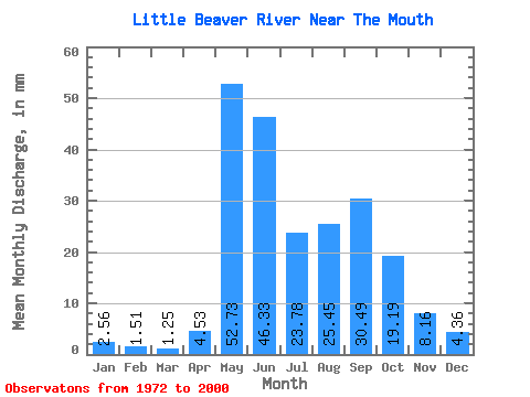
| Statistic | Jan | Feb | Mar | Apr | May | Jun | Jul | Aug | Sep | Oct | Nov | Dec | Annual |
|---|---|---|---|---|---|---|---|---|---|---|---|---|---|
| Mean | 2.56 | 1.52 | 1.25 | 4.53 | 52.73 | 46.33 | 23.77 | 25.45 | 30.49 | 19.19 | 8.16 | 4.36 | 216.01 |
| Standard Deviation | 1.58 | 0.97 | 0.79 | 7.12 | 29.16 | 21.89 | 15.86 | 24.75 | 26.21 | 12.33 | 4.65 | 2.53 | 74.09 |
| Min | 0.34 | 0.23 | 0.14 | 0.06 | 10.46 | 18.78 | 7.56 | 2.89 | 1.64 | 2.86 | 1.28 | 0.52 | 104.22 |
| Max | 6.03 | 3.49 | 2.55 | 31.96 | 145.56 | 125.03 | 81.92 | 112.16 | 102.46 | 53.18 | 19.64 | 9.20 | 374.67 |
| Coefficient of Variation | 0.62 | 0.64 | 0.63 | 1.57 | 0.55 | 0.47 | 0.67 | 0.97 | 0.86 | 0.64 | 0.57 | 0.58 | 0.34 |
 Return to R-Arctic Net Home Page