|
|
|||||||||||||||||
| Point ID: 3123 | Downloads | Plots | Site Data | Code: 06EB004 |
|
|
|||||||||||||||||
| Download | |
|---|---|
| Site Descriptor Information | Site Time Series Data |
| Link to all available data | |
| View: | Time Series | All |
| Units: | m3/s |
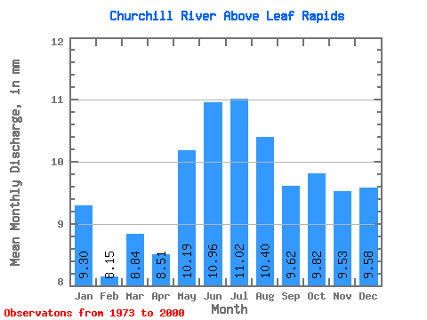
| Statistic | Jan | Feb | Mar | Apr | May | Jun | Jul | Aug | Sep | Oct | Nov | Dec | Annual |
|---|---|---|---|---|---|---|---|---|---|---|---|---|---|
| Mean | 9.03 | 7.98 | 8.58 | 8.27 | 9.90 | 10.65 | 10.71 | 10.10 | 9.34 | 9.54 | 9.26 | 9.31 | 113.52 |
| Standard Deviation | 2.18 | 1.64 | 1.69 | 1.58 | 1.76 | 2.20 | 2.66 | 2.96 | 2.82 | 3.04 | 3.32 | 2.94 | 23.73 |
| Min | 4.59 | 3.99 | 4.33 | 4.37 | 6.94 | 6.07 | 5.98 | 6.07 | 5.80 | 5.60 | 5.11 | 4.89 | 74.09 |
| Max | 16.24 | 12.10 | 11.85 | 10.84 | 13.39 | 15.40 | 16.90 | 17.45 | 16.25 | 16.35 | 20.40 | 20.30 | 158.17 |
| Coefficient of Variation | 0.24 | 0.21 | 0.20 | 0.19 | 0.18 | 0.21 | 0.25 | 0.29 | 0.30 | 0.32 | 0.36 | 0.32 | 0.21 |
 Return to R-Arctic Net Home Page