|
|
|||||||||||||||||
| Point ID: 3111 | Downloads | Plots | Site Data | Code: 05UE004 |
|
|
|||||||||||||||||
| Download | |
|---|---|
| Site Descriptor Information | Site Time Series Data |
| Link to all available data | |
| View: | Time Series | All |
| Units: | m3/s |
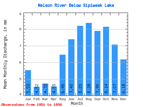
| Statistic | Jan | Feb | Mar | Apr | May | Jun | Jul | Aug | Sep | Oct | Nov | Dec | Annual |
|---|---|---|---|---|---|---|---|---|---|---|---|---|---|
| Mean | 5.53 | 4.56 | 4.72 | 4.55 | 6.45 | 7.40 | 8.20 | 8.38 | 7.90 | 8.14 | 7.07 | 6.17 | 81.13 |
| Standard Deviation | 1.10 | 0.77 | 0.72 | 0.60 | 1.09 | 1.13 | 1.29 | 1.23 | 1.11 | 0.82 | 0.92 | 1.11 | 8.68 |
| Min | 4.35 | 3.70 | 3.98 | 4.08 | 5.38 | 5.93 | 5.97 | 6.04 | 5.80 | 7.16 | 5.83 | 4.88 | 71.58 |
| Max | 7.50 | 5.94 | 5.94 | 5.59 | 8.19 | 9.01 | 10.08 | 10.02 | 9.19 | 9.36 | 8.65 | 8.25 | 94.37 |
| Coefficient of Variation | 0.20 | 0.17 | 0.15 | 0.13 | 0.17 | 0.15 | 0.16 | 0.15 | 0.14 | 0.10 | 0.13 | 0.18 | 0.11 |
 Return to R-Arctic Net Home Page