|
|
|||||||||||||||||
| Point ID: 3110 | Downloads | Plots | Site Data | Code: 05UD004 |
|
|
|||||||||||||||||
| Download | |
|---|---|
| Site Descriptor Information | Site Time Series Data |
| Link to all available data | |
| View: | Time Series | All |
| Units: | m3/s |
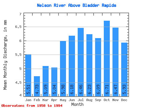
| Statistic | Jan | Feb | Mar | Apr | May | Jun | Jul | Aug | Sep | Oct | Nov | Dec | Annual |
|---|---|---|---|---|---|---|---|---|---|---|---|---|---|
| Mean | 5.51 | 4.77 | 5.09 | 5.04 | 5.98 | 6.18 | 6.46 | 6.22 | 6.09 | 6.71 | 6.47 | 5.93 | 70.79 |
| Standard Deviation | 1.57 | 1.29 | 1.40 | 1.59 | 2.42 | 3.02 | 2.97 | 2.46 | 2.17 | 1.67 | 1.28 | 1.43 | 17.53 |
| Min | 2.29 | 2.02 | 2.07 | 2.12 | 2.48 | 2.35 | 2.11 | 2.03 | 1.96 | 2.77 | 3.59 | 2.29 | 38.67 |
| Max | 8.89 | 7.17 | 7.52 | 8.03 | 11.60 | 11.88 | 12.20 | 11.47 | 10.81 | 10.07 | 9.49 | 9.13 | 99.95 |
| Coefficient of Variation | 0.28 | 0.27 | 0.28 | 0.32 | 0.40 | 0.49 | 0.46 | 0.40 | 0.36 | 0.25 | 0.20 | 0.24 | 0.25 |
 Return to R-Arctic Net Home Page