|
|
|||||||||||||||||
| Point ID: 3104 | Downloads | Plots | Site Data | Code: 05UA003 |
|
|
|||||||||||||||||
| Download | |
|---|---|
| Site Descriptor Information | Site Time Series Data |
| Link to all available data | |
| View: | Time Series | All |
| Units: | m3/s |
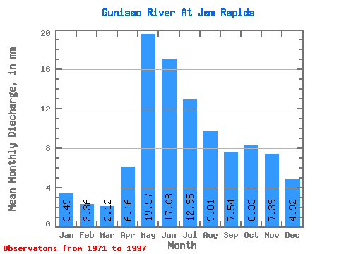
| Statistic | Jan | Feb | Mar | Apr | May | Jun | Jul | Aug | Sep | Oct | Nov | Dec | Annual |
|---|---|---|---|---|---|---|---|---|---|---|---|---|---|
| Mean | 3.49 | 2.38 | 2.12 | 6.16 | 19.56 | 17.08 | 12.95 | 9.80 | 7.54 | 8.33 | 7.39 | 4.92 | 97.54 |
| Standard Deviation | 1.87 | 1.09 | 0.80 | 3.35 | 11.86 | 11.19 | 7.68 | 6.69 | 5.60 | 4.87 | 4.52 | 2.92 | 42.69 |
| Min | 1.01 | 0.95 | 0.48 | 1.52 | 2.14 | 2.14 | 1.05 | 1.02 | 1.55 | 1.53 | 1.68 | 1.10 | 21.36 |
| Max | 7.26 | 5.02 | 3.68 | 14.56 | 43.45 | 53.86 | 30.96 | 29.39 | 22.21 | 18.12 | 19.06 | 12.37 | 203.45 |
| Coefficient of Variation | 0.54 | 0.46 | 0.38 | 0.54 | 0.61 | 0.66 | 0.59 | 0.68 | 0.74 | 0.58 | 0.61 | 0.59 | 0.44 |
 Return to R-Arctic Net Home Page