|
|
|||||||||||||||||
| Point ID: 31 | Downloads | Plots | Site Data | Code: 05AB013 |
|
|
|||||||||||||||||
| Download | |
|---|---|
| Site Descriptor Information | Site Time Series Data |
| Link to all available data | |
| View: | Time Series | All |
| Units: | m3/s |
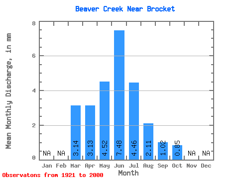
| Statistic | Jan | Feb | Mar | Apr | May | Jun | Jul | Aug | Sep | Oct | Nov | Dec | Annual |
|---|---|---|---|---|---|---|---|---|---|---|---|---|---|
| Mean | 3.14 | 3.13 | 4.52 | 7.49 | 4.46 | 2.12 | 1.03 | 0.85 | |||||
| Standard Deviation | 3.88 | 2.82 | 7.23 | 12.62 | 7.03 | 4.00 | 1.76 | 0.99 | |||||
| Min | 0.08 | 0.16 | 0.02 | 0.00 | 0.00 | 0.00 | 0.00 | 0.00 | |||||
| Max | 14.64 | 11.64 | 44.15 | 65.10 | 26.99 | 22.60 | 10.33 | 5.52 | |||||
| Coefficient of Variation | 1.24 | 0.90 | 1.60 | 1.69 | 1.58 | 1.89 | 1.71 | 1.17 |
 Return to R-Arctic Net Home Page