|
|
|||||||||||||||||
| Point ID: 3092 | Downloads | Plots | Site Data | Code: 05SC002 |
|
|
|||||||||||||||||
| Download | |
|---|---|
| Site Descriptor Information | Site Time Series Data |
| Link to all available data | |
| View: | Time Series | All |
| Units: | m3/s |
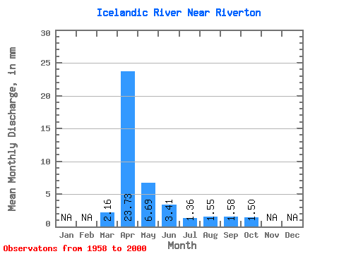
| Statistic | Jan | Feb | Mar | Apr | May | Jun | Jul | Aug | Sep | Oct | Nov | Dec | Annual |
|---|---|---|---|---|---|---|---|---|---|---|---|---|---|
| Mean | 2.16 | 23.73 | 6.69 | 3.41 | 1.36 | 1.55 | 1.58 | 1.50 | |||||
| Standard Deviation | 5.31 | 23.61 | 8.88 | 6.00 | 1.17 | 3.61 | 3.31 | 1.72 | |||||
| Min | 0.02 | 1.42 | 0.60 | 0.41 | 0.18 | 0.12 | 0.21 | 0.39 | |||||
| Max | 32.90 | 101.64 | 45.34 | 37.76 | 6.75 | 19.82 | 20.25 | 7.53 | |||||
| Coefficient of Variation | 2.46 | 0.99 | 1.33 | 1.76 | 0.86 | 2.33 | 2.10 | 1.15 |
 Return to R-Arctic Net Home Page