|
|
|||||||||||||||||
| Point ID: 3091 | Downloads | Plots | Site Data | Code: 05SB005 |
|
|
|||||||||||||||||
| Download | |
|---|---|
| Site Descriptor Information | Site Time Series Data |
| Link to all available data | |
| View: | Time Series | All |
| Units: | m3/s |
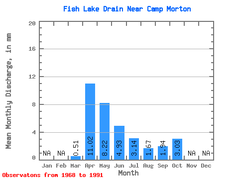
| Statistic | Jan | Feb | Mar | Apr | May | Jun | Jul | Aug | Sep | Oct | Nov | Dec | Annual |
|---|---|---|---|---|---|---|---|---|---|---|---|---|---|
| Mean | 0.52 | 11.02 | 8.22 | 4.93 | 3.13 | 1.66 | 1.94 | 3.02 | |||||
| Standard Deviation | 1.04 | 14.37 | 10.94 | 6.14 | 4.57 | 2.42 | 3.22 | 4.58 | |||||
| Min | 0.00 | 0.04 | 0.00 | 0.00 | 0.00 | 0.00 | 0.00 | 0.00 | |||||
| Max | 4.65 | 61.32 | 40.82 | 21.28 | 17.31 | 9.12 | 11.27 | 17.09 | |||||
| Coefficient of Variation | 2.03 | 1.30 | 1.33 | 1.24 | 1.46 | 1.46 | 1.66 | 1.51 |
 Return to R-Arctic Net Home Page