|
|
|||||||||||||||||
| Point ID: 3076 | Downloads | Plots | Site Data | Code: 05PH003 |
|
|
|||||||||||||||||
| Download | |
|---|---|
| Site Descriptor Information | Site Time Series Data |
| Link to all available data | |
| View: | Time Series | All |
| Units: | m3/s |
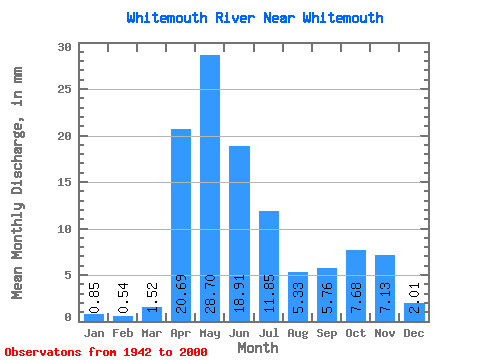
| Statistic | Jan | Feb | Mar | Apr | May | Jun | Jul | Aug | Sep | Oct | Nov | Dec | Annual |
|---|---|---|---|---|---|---|---|---|---|---|---|---|---|
| Mean | 0.85 | 0.55 | 1.52 | 20.69 | 28.70 | 18.91 | 11.85 | 5.33 | 5.76 | 7.68 | 7.13 | 2.01 | 110.57 |
| Standard Deviation | 1.18 | 0.63 | 2.01 | 16.08 | 24.02 | 12.79 | 9.18 | 6.31 | 6.11 | 8.70 | 8.89 | 2.48 | 59.17 |
| Min | 0.03 | 0.05 | 0.00 | 0.61 | 0.55 | 0.21 | 0.18 | 0.22 | 0.07 | 0.12 | 0.09 | 0.06 | 9.59 |
| Max | 6.41 | 3.17 | 11.57 | 61.66 | 102.83 | 46.52 | 44.20 | 28.57 | 20.60 | 43.20 | 48.94 | 11.57 | 240.51 |
| Coefficient of Variation | 1.39 | 1.16 | 1.33 | 0.78 | 0.84 | 0.68 | 0.78 | 1.18 | 1.06 | 1.13 | 1.25 | 1.23 | 0.54 |
 Return to R-Arctic Net Home Page