|
|
|||||||||||||||||
| Point ID: 3066 | Downloads | Plots | Site Data | Code: 05PF063 |
|
|
|||||||||||||||||
| Download | |
|---|---|
| Site Descriptor Information | Site Time Series Data |
| Link to all available data | |
| View: | Time Series | All |
| Units: | m3/s |
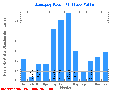
| Statistic | Jan | Feb | Mar | Apr | May | Jun | Jul | Aug | Sep | Oct | Nov | Dec | Annual |
|---|---|---|---|---|---|---|---|---|---|---|---|---|---|
| Mean | 17.23 | 15.60 | 16.72 | 16.66 | 20.20 | 21.08 | 21.82 | 18.04 | 15.96 | 17.00 | 17.36 | 17.87 | 214.67 |
| Standard Deviation | 6.12 | 5.54 | 6.27 | 6.66 | 9.76 | 11.42 | 11.73 | 8.48 | 7.62 | 7.94 | 7.76 | 6.94 | 68.00 |
| Min | 8.21 | 6.48 | 6.68 | 5.64 | 3.17 | 2.53 | 4.13 | 3.92 | 4.73 | 5.91 | 7.49 | 7.86 | 91.73 |
| Max | 33.64 | 29.48 | 32.14 | 35.46 | 48.42 | 56.20 | 56.77 | 53.99 | 45.41 | 53.77 | 43.96 | 38.99 | 386.93 |
| Coefficient of Variation | 0.35 | 0.35 | 0.38 | 0.40 | 0.48 | 0.54 | 0.54 | 0.47 | 0.48 | 0.47 | 0.45 | 0.39 | 0.32 |
 Return to R-Arctic Net Home Page