|
|
|||||||||||||||||
| Point ID: 3040 | Downloads | Plots | Site Data | Code: 05OG006 |
|
|
|||||||||||||||||
| Download | |
|---|---|
| Site Descriptor Information | Site Time Series Data |
| Link to all available data | |
| View: | Time Series | All |
| Units: | m3/s |
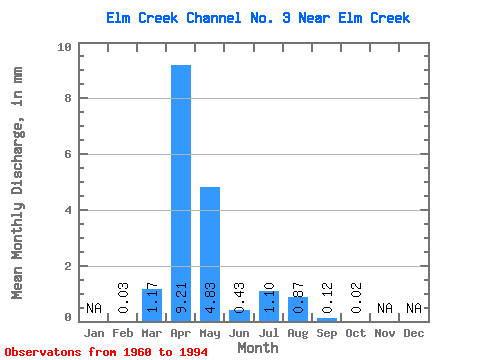
| Statistic | Jan | Feb | Mar | Apr | May | Jun | Jul | Aug | Sep | Oct | Nov | Dec | Annual |
|---|---|---|---|---|---|---|---|---|---|---|---|---|---|
| Mean | 0.04 | 1.18 | 9.21 | 4.83 | 0.43 | 1.10 | 0.86 | 0.12 | 0.02 | ||||
| Standard Deviation | 2.86 | 10.77 | 11.68 | 0.98 | 3.02 | 2.02 | 0.39 | 0.05 | |||||
| Min | 0.04 | 0.00 | 0.00 | 0.00 | 0.00 | 0.00 | 0.00 | 0.00 | 0.00 | ||||
| Max | 0.04 | 13.39 | 38.70 | 46.04 | 4.88 | 11.67 | 6.89 | 1.51 | 0.15 | ||||
| Coefficient of Variation | 2.44 | 1.17 | 2.42 | 2.30 | 2.75 | 2.34 | 3.19 | 2.31 |
 Return to R-Arctic Net Home Page