|
|
|||||||||||||||||
| Point ID: 3038 | Downloads | Plots | Site Data | Code: 05OG004 |
|
|
|||||||||||||||||
| Download | |
|---|---|
| Site Descriptor Information | Site Time Series Data |
| Link to all available data | |
| View: | Time Series | All |
| Units: | m3/s |
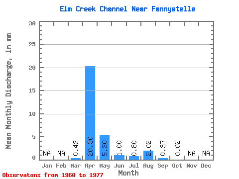
| Statistic | Jan | Feb | Mar | Apr | May | Jun | Jul | Aug | Sep | Oct | Nov | Dec | Annual |
|---|---|---|---|---|---|---|---|---|---|---|---|---|---|
| Mean | 0.42 | 20.30 | 5.30 | 1.00 | 0.80 | 2.02 | 0.36 | 0.02 | |||||
| Standard Deviation | 0.88 | 17.57 | 9.53 | 1.69 | 2.23 | 4.58 | 0.79 | 0.05 | |||||
| Min | 0.00 | 0.06 | 0.04 | 0.00 | 0.00 | 0.00 | 0.00 | 0.00 | |||||
| Max | 3.05 | 55.52 | 37.10 | 6.64 | 9.10 | 15.53 | 2.59 | 0.17 | |||||
| Coefficient of Variation | 2.08 | 0.87 | 1.80 | 1.69 | 2.78 | 2.27 | 2.16 | 2.37 |
 Return to R-Arctic Net Home Page