|
|
|||||||||||||||||
| Point ID: 303 | Downloads | Plots | Site Data | Code: 05BL003 |
|
|
|||||||||||||||||
| Download | |
|---|---|
| Site Descriptor Information | Site Time Series Data |
| Link to all available data | |
| View: | Time Series | All |
| Units: | m3/s |
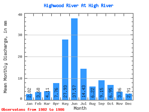
| Statistic | Jan | Feb | Mar | Apr | May | Jun | Jul | Aug | Sep | Oct | Nov | Dec | Annual |
|---|---|---|---|---|---|---|---|---|---|---|---|---|---|
| Mean | 2.82 | 3.71 | 4.11 | 7.76 | 27.92 | 37.57 | 14.43 | 6.22 | 9.15 | 6.95 | 3.86 | 2.91 | 112.22 |
| Standard Deviation | 0.96 | 3.10 | 1.84 | 2.24 | 14.17 | 12.22 | 5.93 | 0.79 | 8.71 | 4.22 | 1.17 | 1.53 | 19.77 |
| Min | 2.03 | 1.56 | 2.52 | 4.59 | 12.20 | 27.23 | 7.41 | 5.14 | 3.77 | 3.72 | 2.92 | 1.76 | 89.90 |
| Max | 4.21 | 8.31 | 7.16 | 10.03 | 50.04 | 55.24 | 21.23 | 7.03 | 22.12 | 13.01 | 5.54 | 5.10 | 127.53 |
| Coefficient of Variation | 0.34 | 0.83 | 0.45 | 0.29 | 0.51 | 0.33 | 0.41 | 0.13 | 0.95 | 0.61 | 0.30 | 0.53 | 0.18 |
 Return to R-Arctic Net Home Page