|
|
|||||||||||||||||
| Point ID: 3026 | Downloads | Plots | Site Data | Code: 05OF014 |
|
|
|||||||||||||||||
| Download | |
|---|---|
| Site Descriptor Information | Site Time Series Data |
| Link to all available data | |
| View: | Time Series | All |
| Units: | m3/s |
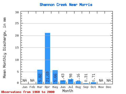
| Statistic | Jan | Feb | Mar | Apr | May | Jun | Jul | Aug | Sep | Oct | Nov | Dec | Annual |
|---|---|---|---|---|---|---|---|---|---|---|---|---|---|
| Mean | 5.82 | 21.03 | 5.66 | 1.43 | 1.98 | 1.15 | 0.31 | 0.71 | |||||
| Standard Deviation | 11.40 | 22.55 | 11.33 | 2.10 | 4.79 | 3.26 | 1.05 | 3.80 | |||||
| Min | 0.00 | 0.21 | 0.00 | 0.00 | 0.00 | 0.00 | 0.00 | 0.00 | |||||
| Max | 53.64 | 85.07 | 46.63 | 11.62 | 22.49 | 15.27 | 6.55 | 24.39 | |||||
| Coefficient of Variation | 1.96 | 1.07 | 2.00 | 1.47 | 2.42 | 2.82 | 3.42 | 5.34 |
 Return to R-Arctic Net Home Page