|
|
|||||||||||||||||
| Point ID: 3011 | Downloads | Plots | Site Data | Code: 05OE008 |
|
|
|||||||||||||||||
| Download | |
|---|---|
| Site Descriptor Information | Site Time Series Data |
| Link to all available data | |
| View: | Time Series | All |
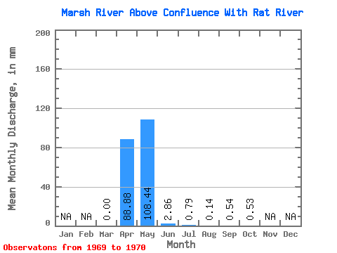
| Units: | m3/s |
| Statistic | Jan | Feb | Mar | Apr | May | Jun | Jul | Aug | Sep | Oct | Nov | Dec | Annual |
|---|---|---|---|---|---|---|---|---|---|---|---|---|---|
| Mean | 0.00 | 88.89 | 108.42 | 2.86 | 0.79 | 0.14 | 0.54 | 0.53 | |||||
| Standard Deviation | 0.00 | 12.98 | 5.87 | 3.43 | 0.36 | 0.15 | 0.68 | 0.71 | |||||
| Min | 0.00 | 79.71 | 104.28 | 0.44 | 0.54 | 0.03 | 0.06 | 0.03 | |||||
| Max | 0.00 | 98.06 | 112.57 | 5.28 | 1.04 | 0.25 | 1.02 | 1.03 | |||||
| Coefficient of Variation | 0.15 | 0.05 | 1.20 | 0.45 | 1.11 | 1.26 | 1.33 |
 Return to R-Arctic Net Home Page